
November 16, 2007
High-tech gear, sleuthing uncover long-lost graves
Caption follows story
A researcher at Southern Illinois University Carbondale, along with a group of high school students, proved that fact once again when they located long-lost graves of early Illinois settlers in a farmer's field. Using high-tech equipment such as ground-penetrating radar, and old-fashioned sleuthing, the group found the circa-1850s cemetery this year, after all surface traces were wiped away 30 years ago.
The find was a triumph for the team and the family, but also might instruct other historic preservationists on how to find the many lost gravesites of the state's settlers, which officials say are disappearing every year.
Harvey Henson, a research project specialist in the Department of Geology, College of Science, led the search after state Historic Preservation Agency officials contacted him in 2004 on behalf of the Strahan family. The family had come to a dead end after years of genealogical research led them to the alleged family cemetery in Randolph County, south of the community of Tilden.
In recent years, Henson has become a regional authority on using non-invasive methods to find lost graves. Last year, Henson received a grant from the National Parks Service and funding from the University to support a search for the graves of Cherokee Indians who died in Southern Illinois during the infamous Trail of Tears forced relocation in 1838-39. During a previous survey, Henson's team confirmed the existence of at least three unmarked graves, prompting the additional grant. He expects to conclude that report soon.
His experience in using scientific instruments to locate sub-surface anomalies made him a perfect choice to help the Strahan, family. Henson saw it as not only that, "but a great opportunity to work with students, too."
"The family had really run out of options. They knew where the cemetery was supposed to be, but it wasn't there. Our information was that sometime in the 1970s it was destroyed." Henson said. "It looked like a great learning experience for students and a way for the University to fulfill its mission of service to the area."
Henson formed a team of high school students from the nearby community of Carterville and with it began working on narrowing down the area where the cemetery might lie within a 600-acre tilled field. The team began by interviewing people who lived around the area, which allowed them to narrow the search down to about 40 acres — still too big to effectively use their sensitive instruments, which can measure down to a matter of inches.
The team then moved to SIUC's Morris Library to search for aerial photographs of the area for clues. They found such shots dating back to the 1940s and moving forward in time.
"The photographs showed how the land use changed over the years and gave us some direction about where the cemetery might be located," Henson said. Eventually, Henson felt certain the lost cemetery lay in an area of about 1,500 square meters.
It was time to do the fieldwork.
In spring 2005, with students in tow, Henson began surveying the suspected area using a variety of instruments including a magnetometer, conductivity meter and ground-penetrating radar. The magnetometer measures the magnetic properties of soil substrate, showing where its typically uniform patterns are disturbed — such as by digging a grave. The electrical conductivity instrument shows water content, which also can indicate substrate disturbances.
Ground-penetrating radar beams light energy into the ground and measures the reflections that bounce back, painting a multi-dimensional portrait of underground soil structures. Henson and his team were able view these images in real time and later analyze them with computer software, which further sharpened the images.
Archaeologists from the state assisted Henson's team and a group of researchers from Eastern Illinois University in Charleston helped by mapping the search area using ground-positioning satellite technology, which would provide consistent, pinpoint location data for the underground pictures and data Henson's team gathered. The group continued working through the fall of 2005 and Henson's team continued analyzing the data for clues after that.
"We had success. We found what we thought were the rough outlines of the cemetery," Henson said. "It was thrilling."
Final confirmation had to wait for March of this year however, when the state hired a contractor to scrape away the top 25 to 50 centimeters of soil where the team thought graves were located. As the backhoe's blade scraped off the topsoil, the dark, grave-sized stains, located in a line, began to emerge.
"It was a very rewarding moment to see all those years of work come to fruition," Henson said. "And it was a great learning experience for all of the researchers and students involved in solving this problem. I know the students will never forget it, and neither will I."
Although the find itself couldn't answer all the family's questions, the landowner gave them permission to construct a monument and fence on the site to mark their ancestors' final resting places. A state archaeology and natural resources group also invited Henson to Springfield to give a presentation this month on how his team located the lost graves.
Despite a cemetery's surface features — headstones and fences — disappearing, the Earth never forgets where it has been disturbed, Henson said.
"Once that soil has been disturbed, you never quite get it packed down like it was before," he said. "We can see that with our instruments."
Henson said finding and preserving such gravesites are important to future generations.
"These cemeteries are being encroached upon and destroyed all the time, through sprawling and changing land use, cultivation and slow degradation," he said. "They are part of our historical record. It's also about respect for the people interred there. It's sort of the right thing to do."
Caption follows story
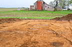
Caption:
Solving the mystery – Dark areas in this picture indicate the presence of unmarked graves discovered by a team of researchers from Southern Illinois University Carbondale recently in a farm field in Randolph County. Led by Harvey Henson, research project specialist in the geology department in the SIUC College of Science, the team set out to find the graves as a research project aimed at helping a family locate the 1850s-era cemetery where their ancestors are interred. The team used non-invasive ways of finding the graves before a backhoe scraped off topsoil to reveal their actual locations and confirm their existence.
Photo provided
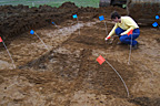
Unmarked graves – A researcher marks areas of suspected unmarked graves discovered by a team of researchers from Southern Illinois University Carbondale recently in a farm field in Randolph County. Led by Harvey Henson, research project specialist in the geology department in the SIUC College of Science, the team set out to find the graves as a research project aimed at helping a family locate the 1850s-era cemetery where their ancestors are interred. The team used non-invasive ways of finding the graves before a backhoe scraped off topsoil to reveal their actual locations and confirm their existence.
Photo provided